You might know that the DRIVING, DRIVING2, SHOOTING and BIPLANE examples from SGL all use a similar method for handling polygon display:
The 3D world consists of a 2D map of polygons and a corresponding map of collision data.
Now I made a tool which converts arbitrary (amounts of)PDATA and XPDATA structures like
to such a 2D map of polygon data.
Being the last tool in the chain, it overcomes size restrictions
that the 3DEditor of SS-SDK for Win95 got.
Conversion is influenced by some options,
such that it can break objects apart at tile boundaries and
merge them together to one inside a tile.
Removal of duplicate points and polygons is partially implemented and will be expanded soon.
Furthermore, I added the possibility to verify the converted data to the original.
Here is the original DRIVING .MDL data together
with 4 different verified and compilable(but DRIVING would need little modification for type MapData) conversions with my tool.
[attachmentid=1073]
Meaning of the filename suffix:
first number is option break_over_tiles,
second is merge_in_tile
The current map format is:
It is superior to that of the DRIVING example, since it allows multiple objects inside a tile, such that (real time gouraud) XPDATA can be mixed with normal PDATA.
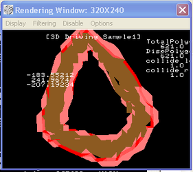
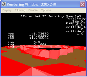
The collision system of those examples instead is not fully clear to me. :huh
I've read some stuff about collision detection,
but it lacks explicit formulas like the book
"Real-Time rendering" got(which I don't have anymore).
It might help if someone else would have a look at the DRIVING source,
especially Collison_put(FIXED x,FIXED y,FIXED z) and tell me what you thing about the those lines:
Any information about ground following(keeping the car flat on the track) would be appreciated, too.
I intent to generate collision info with the tool in the future.
For example the track could be seperated from the rest by texture ids...
The 3D world consists of a 2D map of polygons and a corresponding map of collision data.
Now I made a tool which converts arbitrary (amounts of)PDATA and XPDATA structures like
Code:
POINT	point_BOX[]={

	POStoFIXED( -16.00, 16.00, -16.00),

	POStoFIXED( -16.00, 16.00, 16.00),

	POStoFIXED( 16.00, 16.00, 16.00),

	POStoFIXED( 16.00, 16.00, -16.00),

	POStoFIXED( -16.00, -16.00, 16.00),

	POStoFIXED( 16.00, -16.00, 16.00),

	POStoFIXED( -16.00, -16.00, -16.00),

	POStoFIXED( 16.00, -16.00, -16.00),

};

POLYGON polygon_BOX[]={

	NORMAL(  0,  50,  0), VERTICES( 0, 1, 2, 3),

	NORMAL(  0,  0,  50), VERTICES( 1, 4, 5, 2),

	NORMAL(  0, -50,  0), VERTICES( 4, 6, 7, 5),

	NORMAL(  0,  0, -50), VERTICES( 6, 0, 3, 7),

	NORMAL(  50,  0,  0), VERTICES( 3, 2, 5, 7),

	NORMAL( -50,  0,  0), VERTICES( 1, 0, 6, 4),

};

ATTR attribute_BOX[]={

	ATTRIBUTE(Single_Plane,SORT_CEN,No_Texture,C_RGB(31, 0, 8),No_Gouraud,MESHoff,sprPolygon,UseClip),

	ATTRIBUTE(Single_Plane,SORT_CEN,No_Texture,C_RGB(31,23, 0),No_Gouraud,MESHoff,sprPolygon,UseClip),

	ATTRIBUTE(Single_Plane,SORT_CEN,No_Texture,C_RGB(31, 0, 0),No_Gouraud,MESHoff,sprPolygon,UseClip),

	ATTRIBUTE(Single_Plane,SORT_CEN,No_Texture,C_RGB(31,23, 0),No_Gouraud,MESHoff,sprPolygon,UseClip),

	ATTRIBUTE(Single_Plane,SORT_CEN,No_Texture,C_RGB(10,10,31),No_Gouraud,MESHoff,sprPolygon,UseClip),

	ATTRIBUTE(Single_Plane,SORT_CEN,No_Texture,C_RGB(10,10,31),No_Gouraud,MESHoff,sprPolygon,UseClip),

};

PDATA PD_BOX = {

	point_BOX,sizeof(point_BOX)/sizeof(POINT),

	polygon_BOX,sizeof(polygon_BOX)/sizeof(POLYGON),

	attribute_BOX

};
to such a 2D map of polygon data.
Being the last tool in the chain, it overcomes size restrictions
that the 3DEditor of SS-SDK for Win95 got.
Conversion is influenced by some options,
such that it can break objects apart at tile boundaries and
merge them together to one inside a tile.
Removal of duplicate points and polygons is partially implemented and will be expanded soon.
Furthermore, I added the possibility to verify the converted data to the original.
Here is the original DRIVING .MDL data together
with 4 different verified and compilable(but DRIVING would need little modification for type MapData) conversions with my tool.
[attachmentid=1073]
Meaning of the filename suffix:
first number is option break_over_tiles,
second is merge_in_tile
The current map format is:
Code:
typedef enum {

  IS_EMPTY,

  IS_PDATA,

  IS_XPDATA,

} PdataType;

typedef struct POLYGON_DATA {

  PdataType type;

  XPDATA data;

} PolygonData;

typedef struct TILE_DATA {

  unsigned short nObj;

  PolygonData *obj;

} TileData;

typedef struct POLYGON_MAP {

  // mapSize in tiles

  struct {

    unsigned short x;

    unsigned short y;

  } mapSize;

  // tileSize in world coordinates

  struct {

    FIXED x;

    FIXED y;

  } tileSize, mapOrigin;

  TileData *tiles;

} MapData;
It is superior to that of the DRIVING example, since it allows multiple objects inside a tile, such that (real time gouraud) XPDATA can be mixed with normal PDATA.
The collision system of those examples instead is not fully clear to me. :huh
I've read some stuff about collision detection,
but it lacks explicit formulas like the book
"Real-Time rendering" got(which I don't have anymore).
It might help if someone else would have a look at the DRIVING source,
especially Collison_put(FIXED x,FIXED y,FIXED z) and tell me what you thing about the those lines:
Code:
// what kind of distance is this,

// since it's sx	=(a_collison[aa].cen_x+x)>>16;

// and not sx	=(a_collison[aa].cen_x-x)>>16;

li	=slSquart(sx*sx+sy*sy+sz*sz);

// is this the distance to a plane?

// perpendicular to the plane or to the ground?

col_hight =-(A*((-x-poa)>>16)+B*((-y-pob)>>16))/C-(poc>>16);

// why this fixed point format conversion?

col_x	=A*3;
Any information about ground following(keeping the car flat on the track) would be appreciated, too.
I intent to generate collision info with the tool in the future.
For example the track could be seperated from the rest by texture ids...